| Name | Location | Grade | List Entry |
|---|---|---|---|
| Christ Church | Manchester Rd, Denton | II | 1067969 |
| Church of St Mary | Haughton Green | II | 1067968 |
| Lychgate at Church of St Mary | Haughton Green | II | 1356486 |
| Church of St Anne¹ | St Anne’s Rd, Haughton | I | 1309251 |
| St Anne’s Church Rectory | St Anne’s Rd, Haughton | II* | 1067970 |
| Lychgate and churchyard wall to Church of St Anne and Rectory | St Anne’s Rd, Haughton | II | 1356487 |
| Church of St Lawrence | Stockport Rd, Denton | II* | 1067971 |
| Lychgate at Church of St Lawrence and churchyard wall to west and south | Market St & Town Ln, Denton | II | 1309198 |
| Horse mounting block near Lychgate of Church of St Lawrence | Town Ln, Denton | II | 1356488 |
| St Mary's Church of Our Lady of Sorrows | Duke St/Market St, Denton | II | 1448761 |
| Hyde Hall² | Town Ln, Denton | II* | 1318129 |
| Quadrangle of farm building at Hyde Hall | Town Ln, Denton | II | 1067972 |
| Former hat works at 53 and 55 Stockport Rd | Denton | II | 1163339 |
| Band Stand | Victoria Park, Denton | II | 1163716 |
| War Memorial | Victoria Park, Denton | II | 1430008 |
| Haughton Dale House | Meadow Ln, Haughton Green | II | 1309247 |
| Manor Farmhouse | Haughton Green Rd, Haughton Green | II | 1356485 |
| Former domestic hatting workshop (Bow Garret) | Market St, Denton | II | 1419033 |
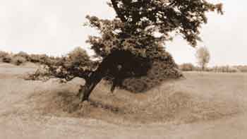
| Section of a boundary ditch known as Nico Ditch³ | Denton Golf Course, 320m south west of Lodge Farm | 1016197 | |
| Tame Viaduct4 | Reddish Vale | II | 1389626 |
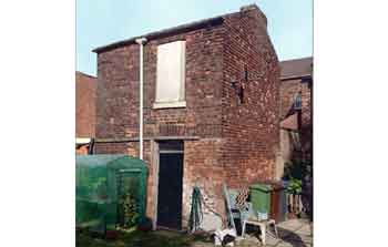 Bow Garret, early 19th century
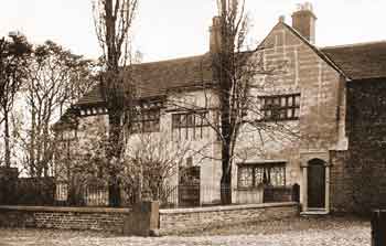 Hyde Hall, 1625
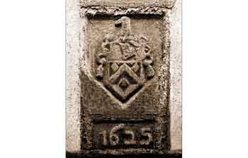 Hyde family Coat of Arms dated 1625
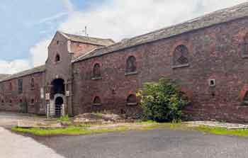 Hyde Hall Farm Buildings, 1687 & 19th century
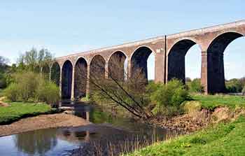 Tame Viaduct, Reddish Vale, 1875
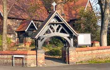 Lychgate & boundary wall at St Anne's Church, Haughton, 1882
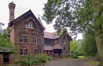 St Anne's Church Rectory, Haughton, 1882
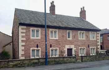 Manor Farmhouse, Haughton Green, 1735
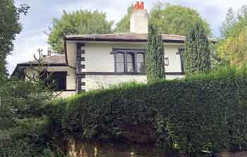 Haughton Dale House, early 19th century
Nico Ditch
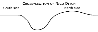
Nico Ditch is the only Scheduled Ancient Monument in Denton and it is a linear boundary of the Anglo-Saxon period. It is ‘U’ shaped in section and about 1.64 to 2.19-yards deep by 4.38-yards wide with a bank on the north side
about 0.55-yards high by 5.45-yards wide at the base. The ‘U’ section, rather than ‘V’ section of the ditch suggests that it was used as a boundary rather than for defensive purposes.
The ditch was about 7.84-miles long, as the crow flies, between Ashton Moss in Ashton-under-Lyne (Grid Ref: SJ 92141 98816) to Ryebank Fields in Chorlton-cum-Hardy (Grid Ref: SJ 81027 94651) and it may have extended through Stretford for a short distance. It passed through Audenshaw (now below Audenshaw Reservoirs), Denton, Gorton, Levenshulme, Rusholme and Fallowfield (Platt Fields Park).
It was constructed sometime between the end of the Roman Era (Roman Legions were withdrawn in 410AD) and the Norman Conquest of 1066. Its original purpose is unknown but the most likely reason for its construction during the Anglo-Saxon period is that it was an administrative boundary; either a 7th century boundary of Anglo-Saxon expansion or a late 8th to early 9th century boundary between the kingdoms of Mercia and Northumbria. One possibility is that it was constructed in the reign of Offa, King of Mercia from 757 until 796AD. In this period the Anglo-Saxon kingdoms of Mercia and Northumbria struggled for control of North West England aggravated by Danish inroads. Eventually the area became part of Danelaw and the river Mersey was the boundary between Mercia and Danelaw.
In addition to the section on Denton Golf Course another scheduled section of Nico Ditch is situated in Platt Fields, Fallowfield, Manchester, off the west side of Wilmslow Rd (53.44671, -2.21893). This is List Entry No. 1015132.
At the western end of this 148-yards-long section of Nico Ditch in Platt Fields (near the boating lake) there is a stone plaque inscribed:
Tameside Scheduled Ancient Monuments
In addition to Nico Ditch in Denton, Tameside has two other Ancient Monuments. These are Buckton Castle in Mossley and a round cairn in Stalybridge.
Buckton Castle, Mossley
This monument is situated on Buckton Moor on top of a sandstone ridge, known as Buckton Hill, off the east side of Moor Edge Road, Mossley. The site is to the north east of Carrbrook, Stalybridge.
It is a medieval ringwork fortification that is likely to have been constructed in the 12th century on the site of a prehistoric hillfort.
Typically, ringworks were fortifications, similar to motte and baileys but without the motte, built and occupied from the late Anglo-Saxon period up to the late 12th century.
They were comprised of a small defended area containing buildings surrounded, or partly surrounded, by a substantial ditch and a bank surmounted by a timber palisade or, rarely, a stone wall.
Occasionally, a more lightly defended embanked enclosure, the bailey, adjoined the ringwork.
In the 17th century Buckton Castle was acquired as a beacon site. These were used to light fires to make a warning of the approach of hostile forces.
This took the form of a smoke signal by day and flames at night. They were always sited on prominent positions and formed part of a chain or group covering most parts of the country.
Buckton Castle is listed as a Scheduled Ancient Monument, List Entry No. 1015131.
Round Cairn, Stalybridge
This monument is located on Wild Bank Hill (Hollingworthhall Moor) to the east of Stalybridge and it consists of a nearly round, flat-topped mound of stones
up to about 2.6-feet high with maximum dimensions of about 20.8 yards by 19.7 yards. The top and the southern edge of the cairn have been partially damaged by the construction
of the Ordnance Survey Wild Bank triangulation point (399m) and a drystone wall, the latter having since been largely removed. The triangulation point is included in the scheduling.
Round cairns are prehistoric funerary monuments dating to the Bronze Age
(c.2000-700 BC). They were constructed as stone mounds covering single or multiple burials. These burials may be placed within the mound in stone-lined compartments called cists.
In some cases a cairn was surrounded by a ditch.
This cairn is listed as a Scheduled Ancient Monument, List Entry No. 1011682.
Nature Reserves & Woods in and around Denton & Haughton
These are situated alongside the river Tame and they include:
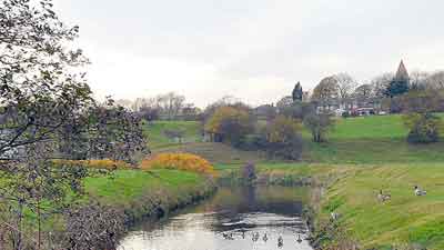
River Tame, Haughton Dale.
Further Reading
Crofton, H T, 1906. Transactions of the Lancashire and Cheshire Antiquarian Society, Agrimensorial Remains Round Manchester, pp. 112-171, Vol. XXIII. Manchester: Richard Gill.
Nevell, Mike (1992). Tameside Before 1066. Tameside Metropolitan Borough Council.
Nevell, Mike (1998). Lands and Lordships in Tameside. Tameside Metropolitan Borough Council with the University of Manchester Archaeological Unit.